


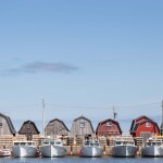

Researchers with the University of British Columbia’s Fisheries Centre are using Google Earth to count fish cages in the Mediterranean and estimate the region’s aquaculture production.
Published in the online journal PLoS ONE on Wednesday, the study claims to be the first to estimate seafood production using satellite imagery.
The researchers hand counted a total of 20,976 finfish cages and 248 tuna cages in the Mediterranean. And, based on that total and available information on cage volume, fish density, harvest rates and seasonal capacity, they placed the region’s aquaculture production at 225,736 metric tons annually, excluding tuna.
While there are reporting discrepancies with individual countries, the researchers concluded that overall the 16 Mediterranean countries are reporting aquaculture production accurately.
“The results are reassuring, and the methods are inspiring,” said co-author Jennifer Jacquet, a post-doctoral researcher with UBC’s Sea Around Us project. “This shows the promise of Google Earth for collecting and verifying data, which means a few trained scientists can use a freely available program to fact-check governments and other large institutions.”
The researchers chose the Mediterranean because accurate reporting of wild-caught fish has been a problem and because the region has excellent satellite coverage. However, not all areas had full satellite coverage, including portions off the coasts of France and Israel.
The study was led by Pablo Trujillo, an oceans science advisor for Greenpeace International, who conducted it as a research assistant at the UBC Fisheries Centre.