


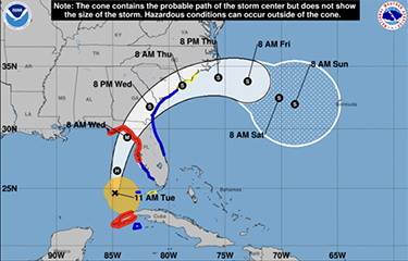
Building into a category 3 hurricane, Hurricane Idalia is moving across the Gulf of Mexico’s deep reservoir of historically warm water, with the National Hurricane Center predicting a path into the U.S. state of Florida’s northern Gulf Coast and landfall the morning of Wednesday, 30 August.
Florida Governor Ron DeSantis declared a state of emergency across 46 counties statewide. Local authorities around the city Tampa Bay ordered a mandatory evacuation, and coastal towns and small fishing ports near Fort Myers, smashed by Hurricane Ian last year, were put on watch, even though forecasters are predicting Idalia will likely track farther north, close to Cedar Key, roughly 80 miles north of Tampa Bay.
With just around 1,000 residents, Cedar Key is in a rural stretch of coast with a large swatch of public wild lands. Spurred by Florida’s shutdown of commercial fishing with nets in 1994, enterprising shellfish growers have made it an aquaculture hub, producing an estimated 90 percent of Florida’s hard clam harvest.
Idalia’s approach is especially dangerous because the storm is anticipated to arrive along with already seasonally high tides at the full moon, Cedar Key Commissioner Sue Colson told the Weather Channel in an interview Monday, 28 August.
National Hurricane Center forecasters said unusually high water temperatures in the Gulf of Mexico are fueling the Idalia’s growth from a tropical storm to category 3 hurricane, with winds expected around 110 miles per hour at landfall.
“Idalia is currently over a maximum of oceanic heat content associated with the Loop Current, and water temperatures remain 30 to 31 degrees Celsius (86 to 87.8 degrees Fahrenheit) along the forecast path up until landfall,” according to a National Hurricane Center forecast. “Vertical shear is also expected to be low for the next 18 to 24 hours, and these conditions are expected to foster rapid intensification before Idalia reaches the coast of Florida. Catastrophic impacts from storm surge inundation of 10 to 15 feet above ground level and destructive waves are expected somewhere between Aucilla River and Yankeetown, Florida. Life-threatening storm surge inundation is likely elsewhere along portions of the Florida Gulf Coast where a storm surge warning is in effect.”
Image courtesy of NOAA