


Upcoming offshore wind projects proposed for areas on the East Coast of the United States will have an impact on NOAA Fisheries surveys, presenting new challenges to scientists by potentially resulting in less-effective fisheries data.
At a special session of the New England Fisheries Management Council covering offshore wind, Wendy Gabriel, of the Northeast Fisheries Science Center, outlined a wide number of concerns for the organization regarding the development of wind power along the coast. Chief among the concerns was the organization’s ability to continue conducting viable fishery surveys – which provide much of the data that the council uses to establish fishing quotas.
“The bottom-line here is, nearly all of the long-term fishery independent surveys that have coverage will be affected,” she said during the session.
There’s already a wide number of potential offshore wind projects planned for the east coast, with multiple leased areas totaling thousands of acres of land dotting the coast. Almost all of those planned areas overlap some of the survey “strata” which NOAA Fisheries uses to plan its surveys.
Typically, according to Gabriel, the center will randomly select areas of each survey “stratum” to determine where trawls will be preformed to get data on certain fisheries – from Atlantic sea scallops to surf clams. However, currently, leased areas overlap in every single strata area; at the lowest end, 30 percent of each strata is occupied by an offshore wind lease.
“Right now, we use a random stratified survey design, and that involves picking locations at random in a stratum, and now we’re not going to be able to do that, because there will be turbines in the neighborhood,” Gabriel said.
That could pose a problem, depending on how spaced out the wind turbines are, and what sort of uses are allowed in the wind energy areas.
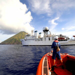
Currently, the science center uses its ship, the Henry B. Bigelow, to perform all trawl surveys. Due to that ship’s size the spacing and size of the turbines could prevent its use in parts of wind energy areas.
“It looks likely that Bigelow would not be operating in an area where the turbine spacing is a nautical mile,” Gabriel said. Due to the nature of the activity, using the Bigelow’s to trawl in areas with closely-spaced turbines could pose risks to both the ship and the turbines.
The height of the turbines will also have an impact.
“The vessel has about 85 feet of air draft, so like a basketball player and a ceiling fan, it’s not going to be pretty,” she said.
Air surveys, used to find large species – like the North Atlantic right whale – will also be impacted. Currently, those surveys are done at 600 feet from a plane. However, minimum distance over structures for airplanes is 1,000 feet, meaning smaller animals – like dolphins – will be nearly impossible to spot.
The immediately apparent solution is shifting to equipment and survey methods that can still be functional, even if offshore wind projects occupy sections of the coast. However, changing the survey methods means changing what data will result.
“If a new survey is required, calibration will be required to maintain a standardized time series,” Gabriel said. “We pay in terms of information loss until we get that series.”
That lack of a standardized series could mean there’s gaps in the data that NOAA and the various fisheries councils have relied on to set their quotas. But finding those gaps, and doing the work required to either adapt old data to new survey methods to continue the series, isn’t possible with the science center’s current staff and funding levels.
“We don’t have any resources at this point to systematically identify these gaps,” said Gabriel. “Normally what we’d say is ‘We’ll build this plane as we fly it.’ The problem here is, we’ve got no pilots, we’ve got no welders, and we’ve got no steel.”
While for now the impact of offshore wind on the science center’s ability to perform the surveys is still limited, projections indicate that increasing demand for renewable energy will result in more and more wind turbines off the coast.
“There’s goals to increase the use of wind energy to generate electricity in the United States over time,” said Michelle Bachmann, fishery analyst for habitat with NEFMC, during an informational portion of the special session. “On the near-term horizon, you’re looking at about 3,000 megawatts offshore. In a decade or so, 22,000 megawatts, bringing that up to 86,000 megawatts.”
For perspective, there’s projected to be 319 wind turbines offshore by 2020. That number goes up to 2,340 by 2030, and over 9,000 by 2050.
That means determining a solution to the survey issue is going to be necessary sooner or later. That raises yet another question: Who will pay for the work needed?
Ron Smolowitz, of the Fisheries Survival Fund, said he’s been trying to get something out of the wind companies whose new turbines are necessitating the changes.
“I’ve been hounding the wind companies for fishery development funds knowing that the fishing industry is going to have to change their practices,” he told the NEFMC.
According to Jon Hare, a member of the council, funding is still “very much in discussion phase.”
Regardless of how the council, and NOAA, approaches the issue, its clear that any solution is going to be complicated to reach, Peter Hughes, a liaison from the Mid-Atlantic Fisheries Council, said.
“We’re going to have to go out and do some formulation and recalibration and look at different vessels and different gear modifications,” Hughes said. “I know that IBM has a supercomputer, called Watson. I don’t have the questions to feed into Watson, but we’re going to have some questions that need answers, and that may be where they have to come from.”