


A project funded by the Sustainable Aquaculture Innovation Centre (SAIC) is trialing the use of a new 3D digital modeling system to map out and monitor complex marine environments and habitats, with the aim of supporting Scottish seafood producers.
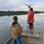
Using remotely operated vehicles (ROVs) and underwater imaging technology, a team of experts plan to create digital twins of the seabed. The project is being led by Oban-based Tritonia Scientific; with support from the Lyell Centre at Heriot-Watt University, seafood producer Mowi, and SAIC.
Over the next 12 months, and building on existing environmental data sets, Tritonia will develop a digital record of the hard substrate found at selected Mowi sites using a technique known as georeferenced photogrammetry. It is the company’s first breakthrough into aquaculture.
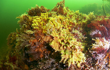
Compared to soft seabeds where samples of sediment can be taken regularly and easily, monitoring hard substrates can be challenging because of the low visibility and hardness of the terrain.
The new system will assess current and future finfish farms, as well as identifying the presence of priority marine features – nationally protected habitats and underwater ecosystems. It is expected that the ROV dives could provide producers with accurate information to aid decision-making, such as the volume and area of specific geographical features.
According to Tritonia Managing Director Martin Sayer, the imaging technology could help the aquaculture sector gain a much more-detailed picture of the sea beds they are operating beside or above.
“Our hope is that the system could ultimately support regulation and environmental monitoring in ways that would provide the levels of evidence that would be necessary for future sustainable operations,” he said.
SAIC CEO Heather Jones said the technology is becoming increasingly important for the aquaculture sector and collaborative research projects and trials can be a valuable demonstration of the real-world applications of new data-led techniques.
“In this case, we could see ROVs and imaging technology playing a vital role in monitoring the sector’s environmental impact and increasing its economic impact by supporting future decisions about farm locations and possible expansion,” she said.
Photo courtesy of Tritonia Scientific